

MoRaU - Monitoring and Modelling of Urbanization in Sub-Saharan Africa
- Contact:
- Project group:
Prof. Stork
- Funding:
Daimler Benz Stiftung
- Partner:
Addis Ababa University; Ethiopian Electric Utility
- Startdate:
01.06.2025
- Enddate:
31.05.2027
MoRaU - Monitoring and Modelling of Urbanization in Sub-Saharan Africa

Urbanization in sub-Saharan Africa is increasing at an extraordinary rate, with thousands of people moving from rural areas to the capital cities in particular every day in search of work, education and a better future. However, the rapid influx poses enormous challenges for city administrations, energy suppliers and transport planners: Roads are becoming congested, electricity grids are reaching their limits and there is a lack of affordable housing in many places. How can this dynamic be shaped to create liveable and sustainable cities? This is the question addressed by the Daimler Benz Foundation-funded research project "Monitoring and Modelling Urbanization in Sub-Saharan Africa", which was launched in June 2025 under the leadership of Prof. Dr. Wilhelm Stork from the Institute of Information Processing Technology at the Karlsruhe Institute of Technology (KIT).
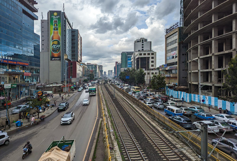
The problem of rapid urbanization can be observed in almost all capital cities in sub-Saharan Africa. The Ethiopian capital Addis Ababa, one of the fastest growing cities in the world, was selected as an example for the project. Growth is currently at 4.4 percent per year. The current population is just under 6 million and is projected to reach 13 million by 2050. This growth is based on the largely uncontrolled influx from the countryside.
Digital twins as tools for sustainable urban development
In developing countries such as Addis Ababa, there is insufficient data for planning infrastructure. The first stage of the project will therefore involve installing a sensor network in a district of Addis Ababa to measure electricity consumption and traffic flow (people, vehicles). In the second part of the project, this data will be linked with city maps and historical urban development in order to create a digital twin of the model district.
The central goal is to create a so-called digital twin - a digital twin of the entire city area of Addis Ababa. This virtual image combines measurement data from various sources, such as the electricity grid, traffic and urban planning. By combining this information, a dynamic model is created that makes the growth of the city visible and analyzable. In future, it will be possible to answer questions such as: In which neighborhoods is energy demand increasing particularly strongly? Where is traffic shifting? Which areas will grow strongly next? The digital twin is intended to help city administrations to target investments - for example in new electricity distributors, bus routes or residential areas.
One particular difficulty faced by many African cities is the lack of reliable data. To close this gap, KIT is working with the College of Technology and Built Environment at Addis Ababa University and the state energy supplier Ethiopian Electric Utility (EEU) to develop a network of intelligent sensors. These small devices record the energy consumption at distribution transformers on the one hand and the traffic flow at important road sections on the other. For data transmission, they use the mobile phone network (GSM/LTE) as a reliable and cost-effective solution, which guarantees stable connections even in densely built-up urban areas. The information obtained is stored in a cloud platform and serves as the basis for the simulations of the digital twin.
Understanding and shaping urbanization
Based on the measurement data and existing city maps, modern geoinformation systems and artificial intelligence are used to create models that show how Addis Ababa has developed to date and how it could change in the future. Various scenarios are then run through: What happens if the proportion of electric vehicles increases sharply? What consequences would the expansion of local public transport have? How do different development strategies affect energy consumption and traffic flow? Such simulations enable urban planners to recognize at an early stage where bottlenecks occur and which measures are most effective in improving the quality of life.
In addition to technical development, the project attaches great importance to capacity building - i.e. the development of knowledge and skills on site. EEU engineers are trained in the use of the models in workshops. Employees from the transport and urban planning departments are also receiving training to integrate the digital tools into their daily work. In the long term, the Ethiopian partners should be able to operate and further develop the system independently. In this way, the project not only contributes to sustainable urban development, but also to strengthening local expertise.
Next steps
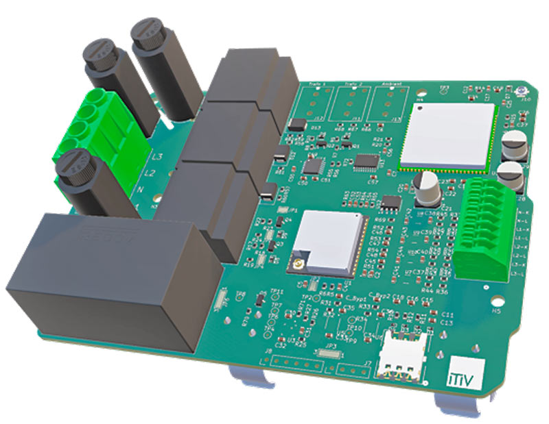
The project is currently in the first phase, in which a model district is being selected. The IoT sensors developed in the predecessor project "Smart-e-Meter" will be improved and expanded to include traffic monitoring. These sensors will then be installed in the model district by EEU technicians. All data will be managed on servers in Ethiopia in order to comply with local data protection guidelines and avoid any dependencies on Germany. The current sensor is shown as a 3D rendering in image (D). In December, Prof. Stork and his team will fly back to Addis Ababa and hopefully carry out initial tests with the new hardware.